|
The owners of the property have attempted to slow the action of erosion by placing stumps and wood in and around the hole.

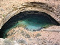
A sinkhole, also known as a sink, snake hole, swallow hole, swallet, doline, or cenote, is a natural depression or hole in the Earth's surface caused by karst processes — for example, the chemical dissolution of carbonate rocks or suffosion processes[2] in sandstone. Sinkholes may vary in size from 1 to 600 metres (3.3 to 2,000 ft) both in diameter and depth, and vary in form from soil-lined bowls to bedrock-edged chasms. Sinkholes may be formed gradually or suddenly, and are found worldwide. The different terms for sinkholes are often used interchangeably.[3]


 Please share your ideas with us.