|

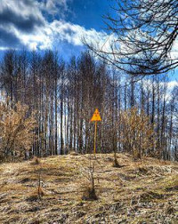
The Red Forest (Ukrainian: Рудий ліс, Russian: Рыжий лес), formerly the Worm Wood Forest, refers to the trees in the 10 km² surrounding the Chernobyl Nuclear Power Plant within the Exclusion Zone. The name 'Red Forest' comes from the ginger-brown colour of the pine trees after they died following the absorption of high levels of radiation from the Chernobyl accident on April 26, 1986. In the post-disaster cleanup operations, the Red Forest was bulldozed and buried in 'waste graveyards'.[2] The site of the Red Forest remains one of the most contaminated areas in the world today.[3]


 Please share your ideas with us.