Wikiplacemarks.com  


Find us on Google+

Ungava Bay (Leaf Basin) tides

View on map:58.780000°N 70.290000°W

Comments

Leaf Basin here has some of the worlds largest tidal ranges (second only to the Bay of Fundy). 

Description


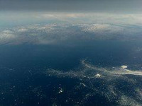
Ungava Bay - Aerial view of north-eastern Ungava Bay close to Cape Chidley, seen from north-west towards south-east. In the foreground is drift-ice, in mid-July.

Ungava Bay (French: baie d'Ungava, Inuktitut (syllabics/Roman) ᐅᖓᕙ ᑲᖏᖅᓗᒃ/ungava kangiqluk) is a large bay in northeastern Canada separating Nunavik (far northern Quebec) from Baffin Island. The bay is roughly oval-shaped, about 260 km (160 mi) at its widest point and about 320 km (200 mi) in length; it has an area of approximately 50,000 km (19,000 sq mi). It is generally fairly shallow, under 150 m (490 ft), though at its border with the Atlantic Ocean depths of almost 300 m (980 ft) are reached.

References

All text is available under the terms of the Creative Commons Attribution-ShareAlike License
Average user rating: Not rated

Click on a star to rate
 

Do you have a form that you would like to turn into an application?

Please share your ideas with us.

Contact us...