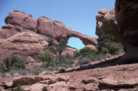
 Jointed rock
38.773801°N 109.590527°W
 The joints in the rock are the first process that begins the arch formation.
 Jointed rock and erosion
38.773391°N 109.590581°W
 The jointed rock here is beginning to differentially erode.
 Skyline Arch
38.774085°N 109.590560°W
 Description by the NPS: "Starting Point: Skyline Arch parking area
Length: 0.4 mile (0.6 km) round trip
Time: 10 to 20 minutes
A short hike on a flat, well-defined trail. On a cold November night in 1940, a large chunk fell out of the arch, instantly doubling the size of its opening."


 Please share your ideas with us.