|

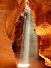
Upper Antelope Canyon is called Tsé bighánílíní, "the place where water runs through rocks" by the Navajo. It is the most frequently visited by tourists, due to two considerations. First, its entrance and entire length are at ground level, requiring no climbing. Second, beams (shafts of direct sunlight radiating down from openings in the top of the canyon) are much more common in Upper than in Lower. Beams occur most often in the summer months, as they require the sun to be high in the sky. Winter colors are a little more muted like the photo displayed here. Summer months provide two types of lighting. Light beams start to peek into the canyon March 15 and disappear October 7 each year.


 Please share your ideas with us.