|

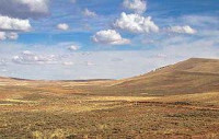
South Pass (elevation 7,412 feet (2,259 m) and 7,550 feet (2,300 m)) is the collective term for two mountain passes on the Continental Divide in the Rocky Mountains in southwestern Wyoming. The passes are located in a broad low region, 35 miles (56 km) wide, between the Wind River Range to the north and the Oregon Buttes and Great Divide Basin to the south, in southwestern Fremont County, approximately 35 miles (56 km) SSW of Lander. South Pass is the lowest point on the Continental Divide between the Central Rocky Mountains and the Southern Rocky Mountains. The passes furnish a natural crossing point of the Rockies. The historic pass became the route for emigrants on the Oregon, California, and Mormon trails to the West during the 19th century. It has been designated as a U.S. National Historic Landmark.


 Please share your ideas with us.