|

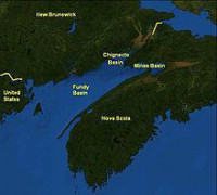
The Fundy Basin is a sediment-filled rift basin on the Atlantic coast of southeastern Canada. It contains three sub-basins; the Fundy sub-basin, the Minas Basin and the Chignecto Basin. These arms meet at the Bay of Fundy, which is contained within the rift valley. From the Bay of Fundy, the Minas Basin trends northeast to Nova Scotia. Chignecto Bay runs from the Bay of Fundy northwest between New Brunswick and Nova Scotia which is separated from the waters of the Northumberland Strait by the Isthmus of Chignecto. The Fundy Basin is best known for the bay it contains. The Bay of Fundy is home to huge tidal changes and tidal bores. It is part of the system of Eastern North America Rift Basins.


 Please share your ideas with us.