 http://upload.wikimedia.org/wikipedia/commons/thumb/b/bf/Da_m%C3%B8ns_klint.jpg/300px-Da_m%C3%B8ns_klint.jpg
, (English:
the Cliffs of Møn), is a striking landmark and tourist attraction along the eastern coast of the Danish island of
Møn in the
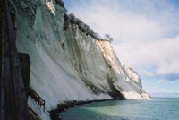
Baltic Sea. The bright
chalk cliffs stretch some 6 km from the park of
Liselund in the north to the
lighthouse in the south. Some of the cliffs fall a sheer 120 m to the sea below. The area around Møns Klint consists of woodlands, pastures, ponds and steep hills, including
Aborrebjerg which, with a height of 143 m, is one of the highest points in Denmark. The cliffs and adjacent park are now protected as a nature reserve. Møns Klint is popular with tourists from across Europe with some 250,000 visitors a year.
[1] There are clearly marked paths for walkers, riders and cyclists. The path along the cliff tops provides impressive views and leads to steps down to the shore in several locations.


 Please share your ideas with us.