|

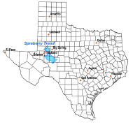
The Spraberry Trend (also known as the Spraberry Field, Spraberry Oil Field, and Spraberry Formation) is a large oil field in the Permian Basin of west central Texas, covering large parts of six counties, and having a total area of approximately 2,500 square miles (6,500 km). It is named for Abner Spraberry, the Dawson County farmer who owned the land containing the 1943 discovery well.[1] The Spraberry Trend is itself part of a larger oil-producing region known as the Spraberry-Dean Play, within the Midland Basin. Discovery and development of the field began the postwar economic boom in the nearby city of Midland in the early 1950s. The oil in the Spraberry, however, proved difficult to recover. After about three years of enthusiastic drilling, during which most of the initially promising wells showed precipitous and mysterious production declines, the area was dubbed "the world's largest unrecoverable oil reserve."[2]


 Please share your ideas with us.