|
The water coming from the flood went through anastomosis flowing outside the valleys depositing bars with current marks that can be seen throughout this area. Stop 1 in Baker et al.
"Bretz et al. (1956, p. 977–980) and Bretz (1959, p. 38–39) highlight this area for its association of gravel bars with giant current ripples, as well as trenched spur buttes that developed when the insides of bedrock meander bends were scoured by the high-velocity megaflood waters (Fig. 19). The bars are composed of coarse gravel and boulders that are organized into foreset bedding that dips in a down-flow direction. Giant current ripples (subfluvial dunes) occur on 16 bar surfaces in this area (Baker, 1973a). Most of these are pendant bars: flow-streamlined mounds of gravel that accumulate downstream from bedrock projections on the scabland channel floors. The projections can be knobs or buttes of basalt, or they may involve the inside bends of preflood meandering bedrock valley. In this area, the bar surfaces are generally ~30 m above the floors of the pre-flood valleys and ~30–60 m below the local high-water marks for the megaflooding (Baker, 1973a). The bars are ~1–2 km in length."

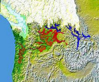
The Missoula Floods (also known as the Spokane Floods or the Bretz Floods) refer to the cataclysmic floods that swept periodically across eastern Washington and down the Columbia River Gorge at the end of the last ice age. The glacial flood events have been researched since the 1920s. These glacial lake outburst floods were the result of periodic sudden ruptures of the ice dam on the Clark Fork River that created Glacial Lake Missoula. After each ice dam rupture, the waters of the lake would rush down the Clark Fork and the Columbia River, flooding much of eastern Washington and the Willamette Valley in western Oregon. After the rupture, the ice would reform, creating Glacial Lake Missoula again.


 Please share your ideas with us.