Wikiplacemarks.com  


Find us on Google+

San Andreas Fault marked by poles along earthquake trail

View on map:38.041150°N 122.796260°W

Comments


San Andreas Fault marked by blue poles
38.041112°N 122.796209°W

The blue posts mark the San Andreas fault along earthquake trail.
Description


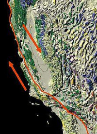
San Andreas Fault

The San Andreas Fault is a continental transform fault that runs a length of roughly 810 miles (1,300 km) through California in the United States. The fault's motion is right-lateral strike-slip (horizontal motion). It forms the tectonic boundary between the Pacific Plate and the North American Plate.

References

All text is available under the terms of the Creative Commons Attribution-ShareAlike License
Average user rating: Not rated

Click on a star to rate
 

Do you have a form that you would like to turn into an application?

Please share your ideas with us.

Contact us...