Wikiplacemarks.com  


Find us on Google+

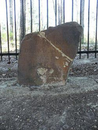
Ellicott's Stone

View on map:30.997808°N 88.022517°W

Description


Ellicott's Stone

Ellicott’s Stone, also known as the Ellicott Stone, is a boundary marker in northern Mobile County, Alabama. It was placed on April 10, 1799 by a joint U.S.-Spanish survey party headed by Andrew Ellicott.[3] It was added to the National Register of Historic Places on 11 April 1973.[1]

References

All text is available under the terms of the Creative Commons Attribution-ShareAlike License
Average user rating: Not rated

Click on a star to rate
 

애플리케이션으로 만들고 싶은 양식이 있으십니까?

좋은 아이디어 있으시면 저희에게 알려주십시오.

Contact us...