|

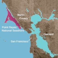
Point Reyes National Seashore is a 71,028-acre (287.44 km2) park preserve located on the Point Reyes Peninsula in Marin County, California, USA. As a national seashore, it is maintained by the US National Park Service as a nationally important nature preserve within which existing agricultural uses are allowed to continue. Clem Miller, a US Congressman from Marin County wrote and introduced the bill for the establishment of Point Reyes National Seashore in 1962 to protect the peninsula from residential development which was proposed at the time for the slopes above Drake's Bay. Miller's vision included the continuation of the historic ranching and oyster farming along with the preservation of the grasslands and open scenic vistas. The mix of commercial and recreational uses was the reason the area was designated a National Seashore rather than a National Park. All of the park's beaches were listed as the cleanest in the state in 2010.


