|

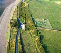
Milefortlet 21 (Swarthy Hill) was a Milefortlet of the Roman Cumbrian Coast defences. These defences were contemporary with defensive structures on Hadrian's Wall. Its remains exist as reconstructed turf ramparts (to a height of about 1 metre (3.3 ft)) and ditch, reinstated to its original profile (also around 1 metre (3.3 ft)). They are located on a low cliff on the coast, north of the village of Crosscanonby, and just inland from the coastal road. It is the only milefortlet to have been fully excavated and is open to the public.


