|

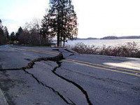
The Nisqually earthquake was an intraslab earthquake, occurring at 10:54 am PST (18:54 UTC) on February 28, 2001. One of the largest recorded earthquakes in Washington state history, it measured 6.8 on the moment magnitude scale and lasted approximately 45 seconds. The epicenter of the earthquake was Anderson Island, about 17 km (11 mi) northeast of Olympia. The focus was at a depth of 52 km (32 mi). Tremors were felt as far away as Scio, Oregon, across the border in Vancouver, British Columbia, Canada, and 175 mi (282 km) east in Pasco, Washington. There were also reports that it was felt as far away as Spokane, Washington and Sandpoint, Idaho.


