|

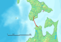
The Seikan Tunnel (青函トンネル Seikan Tonneru or 青函隧道 Seikan Zuidō) is a 53.85-kilometre (33.46 mi) railway tunnel in Japan, with a 23.3-kilometre (14.5 mi) long portion under the seabed. The track level is about 140 metres (460 ft) below the seabed and 240 m (790 ft) below sea level. It travels beneath the Tsugaru Strait — connecting Aomori Prefecture on the Japanese island Honshu and the island Hokkaido — as part of the Kaikyo Line of Hokkaido Railway Company. The name Seikan comes from combining the on'yomi readings of the first characters of Aomori (青森) and Hakodate (函館), the nearest major city on the Hokkaido side.


Proszę podzielić się swoimi pomysłami z nami.
Skontaktuj się z nami...