|
Note the bedrock below the ice.
Note the dirty layer in the ice. This could be a volcanic ash deposit on top of the ice when it was at the surface.

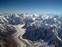
A glacier (UK pron.: /ˈɡlæsiə/ GLASS-ee-ər or US /ˈɡleɪʃər/ GLAY-shər) is a large persistent body of ice that forms where the accumulation of snow exceeds its ablation (melting and sublimation) over many years, often centuries. Glaciers slowly deform and flow due to stresses induced by their weight, creating crevasses, seracs, and other distinguishing features. They also abrade rock and debris from their substrate to create landforms such as cirques and moraines. Glaciers form only on land and are distinct from the much thinner sea ice and lake ice that form on the surface of bodies of water.


 Please share your ideas with us.