|

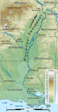
The Mississippi Embayment is a physiographic feature in the south-central United States, part of the Mississippi Alluvial Plain. It is essentially a northward continuation of the fluvial sediments of the Mississippi River Delta to its confluence with the Ohio River at Cairo, Illinois. The embayment is a topographically low-lying basin that is filled with Cretaceous to recent sediments. The northern end of the embayment appears as an anomalous break in regional geologic structure with Paleozoic sedimentary rocks both to the east in Kentucky and Tennessee and to the west in Missouri and Arkansas. The current sedimentary basin results from the filling of a Cretaceous tectonic basin and existed as a large bay in the Cretaceous through early Tertiary shoreline.


 Please share your ideas with us.