|

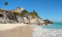
Tulum (Yucatec: Tulu'um) is the site of a Pre-Columbian Maya walled city serving as a major port for Cobá. The ruins are situated on 12-meter (39 ft) tall cliffs, along the east coast of the Yucatán Peninsula on the Caribbean Sea in the state of Quintana Roo, Mexico.[1] Tulum was one of the last cities inhabited and built by the Mayans; it was at its height between the 13th and 15th centuries and managed to survive about 70 years after the Spanish began occupying Mexico. Old World diseases brought by the Spanish settlers appear to have been the cause of its demise. One of the best-preserved coastal Maya sites, Tulum is today a popular site for tourists.[1]


 Please share your ideas with us.