|

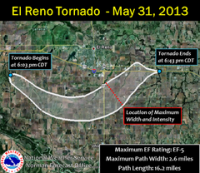
During the early evening of May 31, 2013, the widest and second-strongest tornado in recorded history, according to radar analysis, occurred over rural areas of central Oklahoma. Part of a larger weather system that produced dozens of tornadoes over the preceding days, the tornado initially touched down at 6:03 p.m. CDT (2303 UTC) about 8.3 miles (13.4 km) west-southwest of El Reno, Oklahoma. The storm rapidly grew and became more violent. Remaining over mostly open terrain, the tornado did not impact many structures; however, measurements from mobile Doppler radars revealed extreme winds in excess of 295 mph (475 km/h) within the tornado. As it crossed Highway 81, it had grown to a record-breaking width of 2.6 miles (4.2 km). Turning northeastward, the tornado soon weakened. After crossing Interstate 40, the tornado dissipated around 6:43 p.m. CDT (2343 UTC), after tracking for 16.2 miles (26.1 km).


 Please share your ideas with us.