|

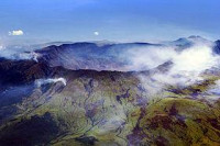
Mount Tambora (or Tamboro) is an active stratovolcano on the island of Sumbawa, Indonesia. Sumbawa is flanked both to the north and south by oceanic crust, and Tambora was formed by the active subduction zone beneath it. This raised Mount Tambora as high as 4,300 m (14,100 ft), making it, in the 18th century, one of the tallest peaks in the Indonesian archipelago. After a large magma chamber inside the mountain filled over the course of several decades, volcanic activity reached a historic climax in the eruption of 10 April 1815.[5] This eruption was approximately VEI-7, the only eruption unambiguously confirmed of that size since the Lake Taupo eruption in about 180 CE.[6] (The Heaven Lake eruption of Baekdu Mountain in c. 969 CE may have also been VEI-7.)


 Please share your ideas with us.