|

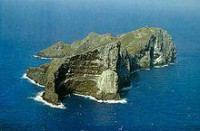
Nihoa (/niːˈhoʊ.ə/; Hawaiian: [niˈhowə]), also known as Bird Island or Moku Manu, is the tallest of ten islands and atolls in the uninhabited Northwestern Hawaiian Islands (NWHI). The island is located at the southern end of the NWHI chain, 296 km (160 nmi) southeast of Necker Island. Nihoa is the closest NWHI in proximity to the eight main windward Hawaiian Islands at approximately 240 km (130 nmi) northwest of the island of Kauaʻi. The island has two peaks, 272 m (892 ft) Miller's Peak in the west, and 259 m (850 ft) Tanager Peak in the east. Nihoa's area is about 171 acres (0.69 km) and is surrounded by a 142,000-acre (57,000 ha) coral reef. Its jagged outline gives the island its name, Nihoa, which means "tooth" in the Hawaiian language.[1]


 Please share your ideas with us.