|
The Crystal Springs Reservoir to the resides within the San Andreas Fault Zone. During the 1906 San Francisco earthquake there was about 4 meters of movement along the fault in this area (right-lateral motion). The movement caused water pipes to rupture and the city was without water to put out the fires. The rocks along the walkway to the vista point are greenstones (metamorphosed basalts) and cherts from the accreted plate (see stop 1 in the referenced guidebook).

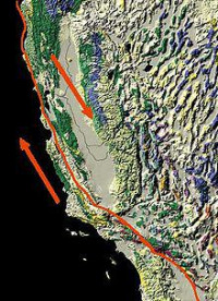
The San Andreas Fault is a continental transform fault that runs a length of roughly 810 miles (1,300 km) through California in the United States. The fault's motion is right-lateral strike-slip (horizontal motion). It forms the tectonic boundary between the Pacific Plate and the North American Plate.


 Please share your ideas with us.