Wikiplacemarks.com  


Find us on Google+

Rushmore Cave

View on map:43.874472°N 103.331867°W

Comments


Rushmore Cave
43.874540°N 103.332113°W

The narrow path through the cave is formed by dissolution along fractures in the limestone.


Column in Rushmore Cave
43.874490°N 103.331571°W

The column forms when a stalactite and stalagmite come together.
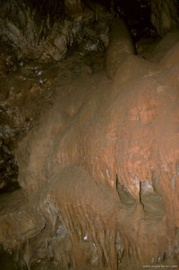

Flowstone in Rushmore Cave
43.874819°N 103.331995°W

Sheets of water deposit layers of calcium carbonate.


Stalactites in Rushmore Cave
43.874022°N 103.331528°W

Some of the thinner stalactites are called soda straws.


Depositional feature in Rushmore Cave
43.874123°N 103.331791°W

The feature forms like a stalactite but is drawn out because of the wind in the cave of water flows in from a fracture.

Many interesting geological features exist in the cave.

Description


Rushmore Cave

Rushmore Cave is the 9th longest cave in South Dakota. It measures a distance of 3,652.6 feet (1,113.3 m). It is located in the Black Hills National Forest, East of Mount Rushmore.

References

All text is available under the terms of the Creative Commons Attribution-ShareAlike License
Average user rating: Not rated

Click on a star to rate
 

Do you have a form that you would like to turn into an application?

Please share your ideas with us.

Contact us...