|

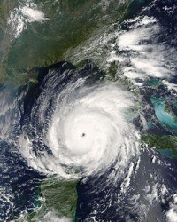
Hurricane Rita was the fourth–most intense Atlantic hurricane ever recorded and the most intense tropical cyclone ever observed in the Gulf of Mexico. Part of the record-breaking 2005 Atlantic hurricane season, which included three of the six most intense Atlantic hurricanes ever (along with #1 Wilma and #6 Katrina), Rita was the eighteenth named storm, tenth hurricane, and fifth major hurricane of the 2005 season. Rita formed near The Bahamas from a tropical wave on September 18 that originally developed off the coast of West Africa. It moved westward, and after passing through the Florida Straits, Rita entered an environment of abnormally warm waters. It rapidly intensified to reach peak winds of 180 mph (285 km/h) on September 20. After steadily weakening and beginning to curve to the northwest, Rita gradually weakened and made landfall on Sabine Pass, Texas with winds of 120 mph (195 km/h) on September 24. It weakened over land and degenerated into a large low-pressure area over the lower Mississippi Valley on September 26.


 Please share your ideas with us.