|

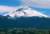
Popocatépetl (Spanish ![]() [popoka'tepetl̩] (help·info) Nahuatl /popoːkaˈtepeːt͡ɬ/) is an active volcano, located in the states of Puebla, State of Mexico, and Morelos, in Central Mexico, and lies in the eastern half of the Trans-Mexican volcanic belt. At 5,426 m (17,802 ft) it is the second highest peak in Mexico, after the Pico de Orizaba at 5,636 m (18,491 ft).
[popoka'tepetl̩] (help·info) Nahuatl /popoːkaˈtepeːt͡ɬ/) is an active volcano, located in the states of Puebla, State of Mexico, and Morelos, in Central Mexico, and lies in the eastern half of the Trans-Mexican volcanic belt. At 5,426 m (17,802 ft) it is the second highest peak in Mexico, after the Pico de Orizaba at 5,636 m (18,491 ft).


 Please share your ideas with us.