|

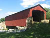
Mary's River Covered Bridge is a covered bridge which crosses Marys River 4 miles (6.4 km) northeast of Chester, Illinois. The Burr truss bridge is 86 feet (26 m) long and 17 feet 8 inches (5.38 m) wide. The bridge was built in 1854 as part of a plank toll road connecting Chester to Bremen; the bridge allowed agricultural products to be transported to Chester, a significant port on the Mississippi River. In the early 1870s, the toll road and the bridge were sold to Randolph County. The bridge served road traffic until 1930.[3]


 Please share your ideas with us.