|

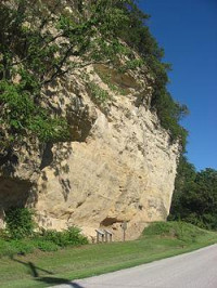
Modoc Rock Shelter is a rock cliff at the edge of the Mississippi River Valley that was undercut by Ice Age floods. This site is significant for its archaeological evidence of the Archaic period in the Eastern United States. The site has over 28 feet of sediment that contain artifacts. Evidence from the site, including four separate periods of Archaic occupation and one of a later period, suggests that the cultures of the Eastern Woodlands may have been comparable in age to the big game hunting cultures of the Great Plains. Based on the analysis of artifacts, archaeologists discovered that 9,000 years ago this rock shelter was used as a short-term camp by small hunting groups; by 6,000 years ago this rock shelter was used for long-term based camps by several families which were involved in activities of everyday life; and, by around 4,000 years ago evidence found in the sediment layers suggests the site was again used by small hunting parties as a short-term camp. There tools included concave projectile points, scrapers, choppers, hammer stones, and bone awls. Evidence has shown that during occupation, the inhabitants had a diet that consisted of deer, raccoon, opossum, birds, and fish.


 Please share your ideas with us.