|
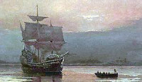
The picture is taken from the deck of the Mayflower II looking toward the long spit called Long Island. The original Mayflower anchored just off the spit in deep water. 6/20/2012 3:39:23 PM
Dec. 15, 1620 - the Mayflower moved from Provincetown Harbor to Plymouth Harbor and anchored approximately here. Philbrick states: "Both Plymouth Harbor and Duxbury Bay to the north are contained within two interlocking sickles of sand: the Gurnet, an extension of Duxbury Beach to the north and Long Beach to the south [looks like a spit]. The Mayflower anchored just within the Goose point at the end of Long Beach, a mile and a half from Plymouth Rock."
Apr. 5, 1621 - the Mayflower returned to England never to return.
Jack Crane

The Mayflower was the ship that in 1620 transported 102 English Pilgrims, including a core group of Separatists, to New England. Their story is one of travail and survival in a harsh New World environment.


 Please share your ideas with us.