Wikiplacemarks.com  


Find us on Google+

Natural Bridge (Virginia)

View on map:37.628002°N 79.544765°W

Comments

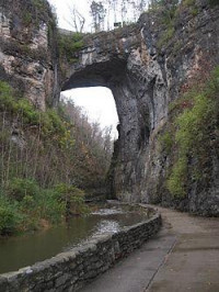
The Great Appalachian Valley here in Virginia is underlain by limestone which is susceptible to dissolution and cave formation.  Natural bridge is 215 feet above the river that flows underneath with a 90 foot span which formed in the 470 million year old Beekmantown dolomite and Chepultepec limestone.  Thomas Jefferson describe the bridge which was part of his land.  The bridge was actually at one time part of a cave system that has collapsed away leaving the bridge.  

Description


Natural Bridge (Virginia)

Natural Bridge in Rockbridge County, Virginia, is a geological formation in which Cedar Creek (a small tributary of the James River) has carved out a gorge in the mountainous limestone terrain, forming a natural arch 215 ft (65.532 m) high with a span of 90 ft (27.432 m). It consists of horizontal limestone strata, and is the remains of the roof of a cave or tunnel through which the creek once flowed. Natural Bridge has been designated a Virginia Historic Landmark and a National Historic Landmark.

References

All text is available under the terms of the Creative Commons Attribution-ShareAlike License
Average user rating: Not rated

Click on a star to rate
 

Do you have a form that you would like to turn into an application?

Please share your ideas with us.

Contact us...