|

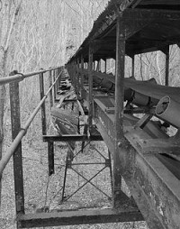
Kay Moor, also known as Kaymoor, is the site of an abandoned coal mine, coal processing plant and coal town near Fayetteville, West Virginia. The town site is located in the New River Gorge at Kaymoor Bottom (38°03′00″N 81°03′17″W / 38.05000°N 81.05472°W). It is linked to the mine portal 560 feet (170 m) above on Sewell Bench (38°02′52″N 81°03′58″W / 38.04778°N 81.06611°W[3]) in the wall of the Gorge by conveyors. The mine exploited the New River Coalfield's Sewell Seam of "smokeless" low-volatile bituminous coal, while the town site was accessible only by the Chesapeake and Ohio Railroad's mainline in the Gorge.[4] The last portion of the Kay Moor complex, Kaymoor Top (38°02′48″N 81°04′09″W / 38.04667°N 81.06917°W[3]) was located at the Gorge rim and served as the terminus for the mountain haulage.[5]


 Please share your ideas with us.