|
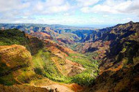
Waimea Canyon State Park -- Waipo'o Falls is in the distance.
Waimea Canyon is over 3,000 ft (900 m) deep and ten miles across (16 km). The Waimea River cut the canyon in a relatively short expanse of geologic time (the oldest volcanic rocks on Kauai date back only 5 million years) partly because of the immense rainfall on the side of Mount Waiʻaleʻale – one of the wettest areas in the world. Waimea means reddish water in Hawaiian and is an obvious reference to the reddish soil exposed throughout the canyon. In high rainfall areas, most chemical elements are carried away through leaching of the rock leaving behind iron oxides and imparting a reddish color to the soil.

Waimea Canyon, also known as the Grand Canyon of the Pacific, is a large canyon, approximately ten miles (16 km) long and up to 3,000 feet (900 m) deep, located on the western side of Kauaʻi in the Hawaiian Islands of the United States. Waimea is Hawaiian for "reddish water", a reference to the erosion of the canyon's red soil. The canyon was formed by a deep incision of the Waimea River arising from the extreme rainfall on the island's central peak, Mount Waiʻaleʻale, among the wettest places on earth.


 Please share your ideas with us.