|

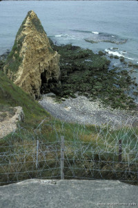
Pointe du Hoc where the Army Rangers scaled the cliff under heavy fire during the invasion of German-controlled France during World War II. June, 1986

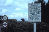
Sign at Pointe du Hoc warning tourists of the potential for live explosives left over from the engagement during D-day. June, 1986

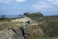
The German installations and bunkers that were bombed and attacked at Pointe du Hoc. June, 1986
Pointe du Hoc is a 100 ft (30 m) high cliff that overlooks the Normandy beach code named Omaha Beach during World War II. It was a crucial German gun installation the allies believed they needed to take out to secure Omaha Beach during the invasion on June 6, 1944 (D-day).
Pointe du Hoc was assaulted by the 2nd Army Ranger Battalion led by Lieutenant Colonel James Earl Rudder in order to remove six 155 mm guns with a range of nearly 14.5 miles (22.9 km). At 06:30 on June 6th, the Rangers attacked the beach below Point du Hoc with ten landing craft and four six-wheel amphibious vehicles (DUKW). The seas were high and rough sinking one of the landing craft along with a supply craft before they reached the beach. As they approached the beach, Rudder realized that the strong tides had carried them nearly 3 miles east of Point du Hoc. By the time they reached the original landing point, another DUKW was sunk by German fire.
The Rangers were finally able to climb the cliffs under heavy fire and subdue German resistance. Unfortunately they did not find the guns in place. The Germans had removed them to a nearby Apple Orchard and placed telephone poles in their place to simulate the guns (the Germans had removed the guns to save them from the heavy bombardment that took place prior to the landings). Meanwhile, the Germans had regrouped and counterattacked the American position forcing them to fall back inside the emplacements. With the help of heavy naval bombardment, they were able to secure their position. By June 7, of the 255 Army Rangers that originally assaulted Pointe du Hoc, more than 150 had been killed or wounded.

Pointe du Hoc (French pronunciation: [pwɛ̃t dy ɔk]) is a clifftop location on the coast of Normandy in northern France. It lies 4 miles (6.4 km) west of Omaha Beach, and stands on 100 ft (30 m) tall cliffs overlooking the sea. Marking the Western end of the Omaha beach sector, it was a point of attack by the United States Army Ranger Assault Group during Operation Overlord in World War II.


 Please share your ideas with us.