|

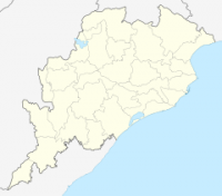
Chudanga Gada was earlier known as Sarangagarh. The fort is situated at a latitude of 20°25’16" north and longitude of 85°48’25" east and at an elevation of 100 feet above sea level. It is about 14 km north of Bhubaneswar in the village Baranga of Cuttack tehsil and district. It is 9.00 km south-west of Cuttack near the Baranga Railway station of the East-coast railways. The site can also be approached from Bhubaneswar through the Bhubanesvar-Cuttack road via Nandankanan and Baranga. From Baranga one has to negotiate a distance of 1.5 km north of Sitaram chowk to reach the site that is situated on the right bank of the river Prachi. The landmarks around the fort are Zoological Park of Nandankanan on its north at a distance of 1.5 km, river Prachi (otherwise known as Baranga River) on its south at a distance of 0.5 km and Chandaka forest closely attached to the fort on its west, and Baranga Police station on its east at a distance of 0.5 km. The site has ruins and vestiges extending over an area more than 1000 acres of land within a fortification made of large sized dressed laterite blocks.


 Please share your ideas with us.