 Ephrata boulder
47.326689°N 119.467205°W
 The huge boulder has a crescent shape to it with scour marks where the water ran around it during the flood. Stop 3 in Baker et al.
"This immense boulder (Fig. 21) measures ~18 × 11 × 8 m. It
has a prominent crescent-shaped scour mark (now mostly filled
with talus) cut into the sediment on the northwest (upstream)
side of the boulder, and an elongate elliptical scour hole on the
southeast (downstream) side. This scour pattern can be explained
by a dual vortex system generated by the blunt obstacle posed
by the boulder to the megaflood flow field during the waning
stages of a flood (Baker, 1973a, 1978c; Baker and Komar, 1987).
The size of this boulder attests to the transport capability of the
megaflood waters (Fig. 10) as they poured through the Soap Lake
constriction point. The boulder consists of basalt entablature, the
interlocking jointing of which likely led to its remaining intact
during transport from outcrops that lie ~8 km to the north. The
many other large boulders in this area are smaller, which may
be the result of their inability to remain intact during transport.
An alternative hypothesis is that this boulder was ice-rafted into
the present location. However, there are many problems with that
hypothesis that will be further discussed on the trip."
 Missoula Floods
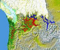
The Missoula Floods (also known as the Spokane Floods or the Bretz Floods) refer to the cataclysmic floods that swept periodically across eastern Washington and down the Columbia River Gorge at the end of the last ice age. The glacial flood events have been researched since the 1920s. These glacial lake outburst floods were the result of periodic sudden ruptures of the ice dam on the Clark Fork River that created Glacial Lake Missoula. After each ice dam rupture, the waters of the lake would rush down the Clark Fork and the Columbia River, flooding much of eastern Washington and the Willamette Valley in western Oregon. After the rupture, the ice would reform, creating Glacial Lake Missoula again.


 Please share your ideas with us.