|
The site is important because it shows how high the Missoula floods reached. There are both unaltered loess deposits and those at lower elevation aligned by the floods. Stop 1 of Pritch and Cebula
"The drainage divide between H U Ranch Coulee (Davin Gorge) and Palouse River, and also Palouse and Snake Rivers contains: (1) areas of scabland topography; (2) streamlined loess islands; and (3) loess hills that are not streamlined, or were not significantly modified by the outburst floods (Fig. 9). These features were interpreted by Bretz et al. (1956) as evidence that floodwaters were at least 427 m (1400 ft) elevation at the divide. This is an important piece of evidence against the competing theory that “normal fluvial erosion” could explain the scabland erosional features (e.g., Flint, 1938). At this stop, we can see streamlined loess hills (once submerged) next to eroded basalt with scabland topography, as well as unsubmerged loess islands to the south (Figs. 3, 6, 9, 10). The prow of the hill is the steep front of the streamlined hills that points into the floodwaters. The loess islands that were not modified are over ~430 m, suggesting that floodwaters did not reach this elevation. Looking at aerial photos (Figs. 6 and 9) we can see each of the three types of loess islands that Baker (1973) described in the Cheney-Palouse Scabland tract (Fig. 10)."

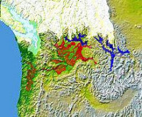
The Missoula Floods (also known as the Spokane Floods or the Bretz Floods) refer to the cataclysmic floods that swept periodically across eastern Washington and down the Columbia River Gorge at the end of the last ice age. The glacial flood events have been researched since the 1920s. These glacial lake outburst floods were the result of periodic sudden ruptures of the ice dam on the Clark Fork River that created Glacial Lake Missoula. After each ice dam rupture, the waters of the lake would rush down the Clark Fork and the Columbia River, flooding much of eastern Washington and the Willamette Valley in western Oregon. After the rupture, the ice would reform, creating Glacial Lake Missoula again.


 Please share your ideas with us.