|

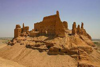
Al-Rahba (/ALA-LC: ar-Raḥbah, sometimes spelled Raḥabah), also known as Qal'at ar-Rahba, which translates as the "Citadel of al-Rahba", is a medieval Arab–Islamic fortress in Syria. It is located off the western banks of the Euphrates River, adjacent to the city of Mayadin and 42 kilometers (26 mi) southeast of Dayr az-Zawr. Situated atop a mound with an elevation of 244 meters (801 ft), al-Rahba oversees the Syrian Desert steppe and historically guarded the Euphrates valley. It has been described as "a fortress within a fortress"; it consists of an inner keep measuring 60 by 30 meters (197 ft × 98 ft), protected by an enclosure measuring 270 by 95 meters (886 ft × 312 ft). Al-Rahba is largely in ruins today as a result of erosion.


 Please share your ideas with us.