|

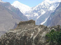
The Hunza Valley (Burushaski: ہنزہ, Urdu: ہنزہ) is a mountainous valley in the Gilgit–Baltistan region of Pakistan. The Hunza valley is situated north/west of the Hunza River, at an elevation of around 2,500 metres (8,200 ft). The territory of Hunza is about 7,900 square kilometres (3,100 sq mi). Aliabad is the main town is while Karimabad is a popular tourist destination because of the spectacular scenery of the surrounding mountains like Ultar Sar, Rakaposhi, Bojahagur Duanasir II, Ghenta Peak, Hunza Peak, Passu Peak, Diran Peak and Bublimotin (Ladyfinger Peak), all 6,000 metres (19,685 ft) or higher.


 Please share your ideas with us.