|

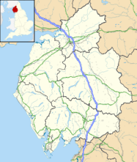
Camboglanna (with the modern name of Castlesteads) was a Roman fort. It was the twelfth fort on Hadrian's Wall counting from the east, between Banna (Birdoswald) to the east and Uxelodunum (Stanwix) to the west. It was almost 7 miles (11 km) west of Birdoswald, on a high bluff commanding the Cambeck Valley. It guarded an important approach to the Wall and also watched the east bank of the Cambeck against raiders from the Bewcastle area. The site was drastically levelled in 1791 when the gardens of Castlesteads House were laid over it. The name “Camboglanna” is believed to mean “Crook Bank”, or "Bent Valley" because it overlooks a bend in the river Irthing.


 Please share your ideas with us.