|

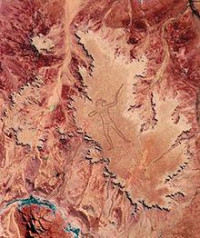
The Marree Man, or Stuart's Giant, is a modern geoglyph discovered by air on 26 June 1998. It appears to depict an indigenous Australian man hunting birds or wallabies with a throwing stick. It lies on a plateau at Finnis Springs 60 km west of the township of Marree in central South Australia. It is just outside the 127,000 square kilometres (49,000 sq mi) Woomera Prohibited Area. The figure is 4.2 km (2.6 mi) tall with a perimeter of 15 by 28 kilometres (9.3 mi × 17 mi). Although it is the second largest geoglyph (and largest non-commercial geoglyph) in the world, its origin remains a mystery, with not a single witness to any part of the expansive operation. The name "Stuart's Giant" was given to it in a fax sent to the media anonymously by those believed to have created the figure, after John McDouall Stuart.


 Please share your ideas with us.