|

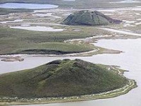
Pingos are intrapermafrost ice-cored hills, ranging in height from 3 to 70 m (10 to 230 ft) and 30 to 1,000 m (98 to 3,281 ft) in diameter. They are typically conical in shape and grow and persist only in permafrost environments, such as the Arctic and subarctic.[2] A pingo is a periglacial landform, which is defined as a non-glacial landform or process linked to colder climates.[3] It is estimated that there are more than 11,000 pingos on Earth.[4] The Tuktoyaktuk peninsula area has the greatest concentration of pingos in the world with a total of 1,350 pingos.[5] There are currently remarkably limited data on pingos.[5]


 Please share your ideas with us.