Wikiplacemarks.com  


Find us on Google+

Columbia River flood basalts

View on map:47.877600°N 119.049398°W

Comments

"The basalt cliffs forming the walls of the canyon are part of the Grande Ronde sequence, which erupted from great fissures near the Washington-Idaho border over a period of about a million years. This was during the Miocene, mainly about 16 million years ago." (see reference)

Description


Columbia River Basalt Group

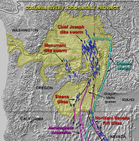
The Columbia River Basalt Group is the youngest, smallest and one of the best-preserved continental flood basalt province on Earth, covering over 210,000 km (81,000 sq mi) mainly eastern Oregon and Washington, western Idaho, and part of northern Nevada.[1] The basalt group includes the Steen and Picture Gorge basalt formations.

References

All text is available under the terms of the Creative Commons Attribution-ShareAlike License
Average user rating: Not rated

Click on a star to rate
 

Do you have a form that you would like to turn into an application?

Please share your ideas with us.

Contact us...