|
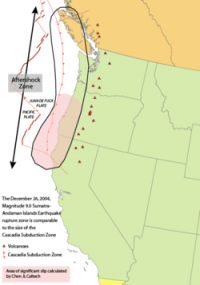
The location of the epicenter of the earthquake is not known but the location here places the earthquake in the subduction zone where it occurred.

The 1700 Cascadia earthquake was a magnitude 8.7 to 9.2 megathrust earthquake that occurred in the Cascadia subduction zone on January 26, 1700. The earthquake involved the Juan de Fuca Plate underlying the Pacific Ocean, from mid-Vancouver Island in British Columbia, Canada, south along the Pacific Northwest coast as far as northern California, USA. The length of the fault rupture was about 1,000 kilometers (620 miles) with an average slip of 20 meters (22 yards).


 Please share your ideas with us.