|

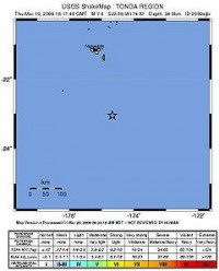
The 2009 Tonga earthquake was a 7.6 magnitude earthquake that occurred off the coast of Tonga on March 19, 2009, at 18:17:41 UTC.[2] It had a depth of around 34 kilometres (21 mi).[1] A tsunami warning was issued in the aftermath of the earthquake, although this was later cancelled.[3] It was followed a short while later by an aftershock earthquake that had a magnitude of 5.3.[2] Two more aftershocks followed on March 20 (UTC), with magnitudes of 5.4 and 5.0 Mw, then another magnitude 5.0 aftershock on March 21, totalling four aftershocks above magnitude 5.[4] The quake occurred approximately 220 kilometres (140 mi) to the southeast of Nuku'alofa, the capital of Tonga,[1] and initial reports suggest that there have been no injuries or significant damage. The earthquake was felt as far away as New Zealand's North Island, over 3,000 kilometres (1,900 mi) away.[2]


 Please share your ideas with us.