Wikiplacemarks.com  


Find us on Google+

Historic Centre of Guimarães

View on map:41.440830°N 8.294820°W

Description


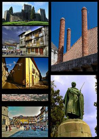
Clockwise from top left:Guimarães Castle, A chimneys at Dukes Braganza Palace, Statue of Dom Afonso Henriques in Ducal Palace, Oliveira Plaza, Panorama view of Guimarães historical heritage area from Mount Penha, Santa Maria Street, Santiago Plaza

Guimarães (Portuguese pronunciation: [ɡimɐˈɾɐ̃jʃ]) is a northern Portuguese city located in the district of Braga, in the Ave Subregion (one of the more industrialized subregions of the country), with a population of 158 124 inhabitants, distributed throughout 20 parishes (freguesias in Portuguese), in an urban area of 23,5 km² with a population density of 2 223,9/km².

References

All text is available under the terms of the Creative Commons Attribution-ShareAlike License
Average user rating: Not rated

Click on a star to rate
 

Do you have a form that you would like to turn into an application?

Please share your ideas with us.

Contact us...