|

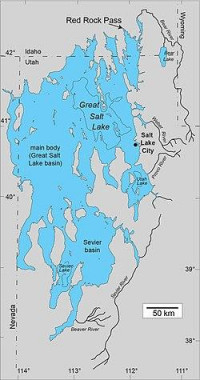
Lake Bonneville was the largest Late Pleistocene paleolake in the Great Basin of western North America. The Western Interior Seaway preceded Lake Bonneville.[2] Lake Bonneville was a pluvial lake that formed in response to an increase in precipitation and a decrease in evaporation as a result of cooler temperatures. Lake Bonneville covered much of what is now western Utah and at its highest level extended into present-day Idaho and Nevada. Many other hydrographically closed basins in the Great Basin contained expanded lakes during the Late Pleistocene, including Lake Lahontan in northwestern Nevada.


