Wikiplacemarks.com  


Find us on Google+

2007 Mozambican flood

View on map:18.544258°S 35.358889°E

2007 Mozambican flood


2007 Mozambican flood

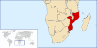
The 2007 Mozambican flood began in late December 2006 when the Cahora Bassa Dam overflowed from heavy rains on Southern Africa. It worsened in February 2007 when the Zambezi River broke its banks, flooding the surrounding areas in Mozambique.[2] The Chire and Rivubue rivers have also flooded.[3]

References

All text is available under the terms of the Creative Commons Attribution-ShareAlike License
Average user rating: Not rated

Click on a star to rate
 
您有一個表格您想把它變成應用程序嗎?
請與我們分享您的意見。