|

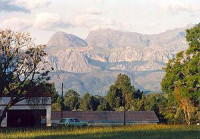
Chimanimani District (part of which was known as Melsetter 1895–1982) is a mountainous area in the province of Manicaland, eastern Zimbabwe. The region is distinguished by large peaks,carved from a rifted quartzite block, the highest reaching to 2440 m (8005 ft) and stretching for some 50 km (31 mi), forming the border with Mozambique. Between the village of Chimanimani and the border the ranges are gentler and more rounded. The national park is in the southernmost area of the Eastern Highlands, and is 150 km (93 mi) from the town Mutare (known as Umtali until 1982).


 Veuillez partager vos idées avec nous.