|

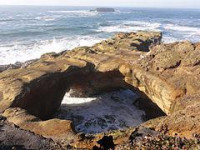
Devils Punch Bowl State Natural Area is a state day use park on the central Oregon Coast in the United States. It is centered on a large bowl naturally carved in a rock headland which is partially open to the Pacific Ocean. Waves enter the bowl and often violently churn, swirl, and foam. Outside the bowl, ocean conditions are attractive to surfers near a large offshore rock pinnacle named Gull Rock, located about 1⁄2 mile (800 m) west-northwest of Devils Punch Bowl, which funnels and concentrates waves easily seen from the park. There are at least seventeen large rocks, part of Oregon Islands National Wildlife Refuge, which provide interesting wave viewing, and attract and provide a home for wildlife.


