|

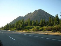
Black Butte is a cluster of overlapping dacite lava domes in a butte, a parasitic satellite cone of Mount Shasta.[5] It is located directly adjacent to Interstate 5 at milepost 742 between the city of Mount Shasta and Weed, California. The highway crosses a 3,912 ft (1,192 m) pass, Black Butte Summit, at the western base of the lava domes. The lava domes were extruded at the foot of the cone of Shastina following the period of its major eruptions about 9,000–10,000 years ago.[2]


Proszę podzielić się swoimi pomysłami z nami.
Skontaktuj się z nami...